Vintage Postcard Aerial View Little Current Manitoulin Island
📸 Click any thumbnail to inspect Front, Back & Angles (2 Photos)
As an eBay Partner, we may earn a commission if you make a purchase.
Item Specifications
- Era: 1960s Chrome
- Publisher: Peterborough Post Card Co.
- Distributor: A. A. Gleason, Jr.
- Location: Little Current, Manitoulin Island, Ontario, Canada
- Subject: Aerial Townscape & Waterfront
- Originality: Original Vintage
- Category: Postcards & Ephemera
- Format / Type: Vintage Postcards
Looking for Modern Alternatives?
Explore top-rated, modern Postcards & Ephemera and related historical accessories on Amazon.
Shop Postcards & Ephemera on Amazon →As an Amazon Associate, we earn from qualifying purchases.
Historical Context & Overview
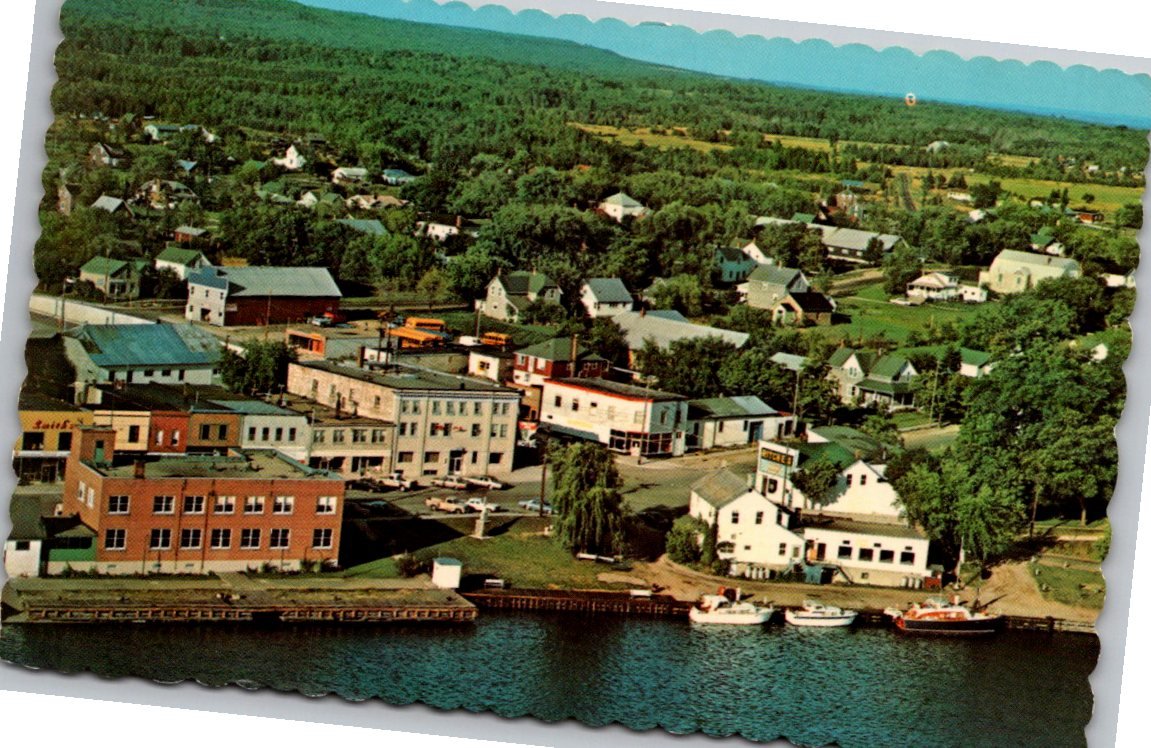
Perched along the narrow channel separating Manitoulin Island from the Ontario mainland, Little Current has long served as the vibrant maritime gateway to the world's largest freshwater island. This vintage chrome-era postcard offers a panoramic aerial perspective of the town, capturing its picturesque waterfront, compact commercial district, and lush northern backdrop. Photographed from an elevated position, the image provides a captivating snapshot of mid-twentieth-century community life and harbor activity in Northern Ontario.
Geographic Significance and Waterfront Heritage
The town of Little Current—known in Anishinaabemowin as Waebijewung, referencing the narrowing of the channel waters—developed around its strategic location on the North Channel of Lake Huron. Historically a bustling hub for commercial shipping, timber transit, and Great Lakes passenger steamships, the community gradually evolved into a premier sanctuary for recreational yachting and island tourism. In this aerial view, pleasure craft and working vessels are docked neatly along the shoreline bulkhead, reflecting the town's enduring connection to regional navigation.
Commercial Architecture and Town Layout
The foreground of the postcard highlights Little Current's historic waterfront streetscape, featuring sturdy multi-story brick commercial buildings, timber frame structures, and vintage automobiles parked along the streets. These storefronts once housed local dry goods merchants, marine outfitters, and family-owned businesses that sustained both permanent island residents and summer visitors. Beyond the commercial core, modest residential homes merge into the expansive, forest-covered topography that defines the Manitoulin landscape.
Aerial view postcards from this period hold exceptional value for regional historians and cartography enthusiasts. They document civic layout, shoreline engineering, and land utilization prior to modern municipal developments, offering a clear visual record of how the community integrated harbor operations with local commerce.
Production Details and Publisher Background
This original postcard was produced in Canada by the Peterborough Post Card Co., based in Peterborough, Ontario. The card showcases distinctive scalloped or deckle-cut edges, a popular aesthetic feature during the 1960s that gave vibrant color photographs a framed, decorative presentation. It was distributed locally by A. A. Gleason, Jr. of South Bay Mouth, a prominent distributor who supplied gift shops, ferry terminals, and general stores throughout Manitoulin Island.
Identified by the production code 35967-C, the reverse side features a clean divided-back format with traditional blue text formatting and a designated stamp box. Preserved in unposted condition, it stands as a prime specimen of mid-century Canadian postcard publishing.
Collector Significance and Preservation
For deltiologists, Ontario regional historians, and cottage country memorabilia collectors, this aerial perspective of Little Current is a cherished historic artifact. It preserves the charm, natural beauty, and architectural character of Manitoulin Island's primary port town during a golden era of Canadian highway and waterway travel.